Uk Hydrographic Office
Billions of people worldwide rely on the oceans for food, work and leisure, collectively known as the blue economy. The good governance of our oceans and the sustainable use of sea resources are crucial to the UK and its Overseas Territories and Crown dependencies, which are custodians to the fifth-largest marine estate in the world. We are responsible for ensuring long-term and effective use of this ocean resource.
Developing and maintaining a good understanding of the oceans is crucial to good governance and blue economic development. However, due to the remoteness, small populations and land masses of the UKs Overseas Territories, this hydrographic data has historically proven challenging to gather, and resources have been lacking to invest in the level of seabed mapping required.
In 2016, these factors drove the UK government to create theOverseas Territories Seabed Mapping Programme(OTSMP). Funded by the UK Government, the programme exists to improve the safety of navigation through hydrography and develop hydrographic capability.
Activity under this programme has increased compliance with international maritime obligations and supports blue economic development for the UKs Overseas Territories. Many of the Overseas Territories are islands, meaning most goods are transported by sea. Ensuring accurate navigational charts helps mariners to navigate safely into port and maintains safe transport links to and from the islands.
Developing hydrographic understanding to support safe navigation
The UK Hydrographic Office (UKHO) is proud to support several Overseas Territories through the OTSMP, including conducting many hydrographic surveys under the survey programme, such as the one conducted in theCayman Islands in 2021, supporting Montserrat authorities with equipment and training to undertake seabed mapping, and over the past eight years working alongside thegovernment of Anguilla to help improve the safety of life at seaaround the island.
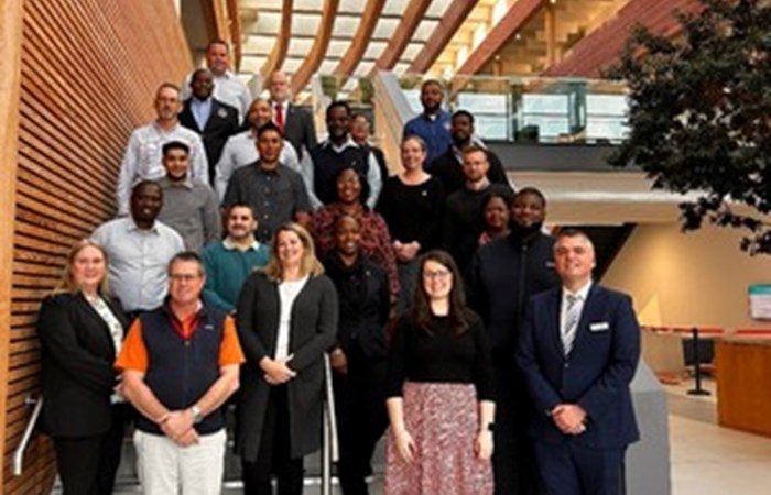
The latest milestone for the OTSMP came in January when the UKHOs hydrographic programmes team hosted 22 delegates from 13 Overseas Territories and Crown Dependencies at the organisations headquarters in Taunton.
The weeklong workshop covered many topics; this included hydrographic governance, international obligations and a day focused on maritime safety information, including how Overseas Territories can continue to develop their hydrographic capabilities. Later in the week, they discussed hydrographic surveying and sharing data, focusing on the future of navigation and identifying risk areas to prioritise future surveying activity.
Speaking about the workshop, and the OTSMP more broadly, Nathanael Knapp, Head of Partnering and Engagement (East Atlantic and Caribbean) at the UKHO, said that the week was critical for
raising awareness within the Overseas Territories of the importance of their obligations under Safety Of Life At Sea, but also provides them with the capability, capacity and infrastructure to be able to deliver on those obligations. This leads to wider benefits, such as improving their economy and other environmental, sustainable benefits
Supporting the long-term future for hydrographic capacity in the Overseas Territories
The workshop helped the Overseas Territories delegates gain a greater understanding of hydrographic governance and how it assists them to improve compliance with their international maritime obligations. For the UKHO, hosting the workshop enabled strong engagement with a wide range of stakeholders.
Darren Kelly, Chief Surveyor for the Cayman Islands Government, said that the week of workshops helped to promote
capacity building that ultimately provides surveys to give us a better understanding and improve safety of navigation in the waters around the Cayman Islands.
Anguillas Director of Maritime Affairs, Sharmer Fleming, pointed out that beyond the immediate SOLAS benefits of the OTSMP, the programme
also contributes to a number of areas such as environmental management, disaster awareness and building resilience to climate change.
And on the long-term future for hydrographic capacity in the Overseas Territories, Lavern Ryan, Geographic Information System Manager for the Government of Montserrat, added that thanks to the OTSMP, Montserrat now has a
a team of eight people that are trained to perform hydrographic surveys.
She also pointed out that
hydrographic surveying is a vital part of our existence its a continual effort because the seabed changes so often.
Overall, the week of workshops provided a fantastic opportunity for collaboration and partnerships across the UKs Overseas Territories. Hydrographic capacity building is an ongoing process, but over time, improved survey data from the UKs Overseas Territories will power improved sustainability, economic and, most importantly, safety benefits for locals, regulators, mariners and vessels.
As a world-leading hydrographic office, the UKHO will continue to work with friends and partners across the globe, supporting the development of hydrographic capability to enhance understanding, management and protection of the marine environment.
Learn about the advantages of the OTSMP and collaboration with the UKHO from attendees at hydrographic data governance workshops. Watch our video: