Natural England

March 6
09:30
2024
Details
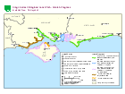
Find out about the work being carried out to improve public access to each stretch of the coast in the south of England.
| Stretch name | Progress |
|---|---|
| Highcliffe to Calshot | Stage 4: Determine |
| Calshot to Gosport | Open to the public |
| Isle of Wight: East Cowes to Wootton Bridge | Stage 2 and 3: Develop and Propose |
| Isle of Wight: Wootton Bridge to the Medina | Stage 4 and 5: Partially approved (not yet available for public use - work to establish the route is currently taking place on approved lengths) |
| Gosport to Portsmouth | Open to the public |
| Portsmouth to South Hayling | Stage 5: Open (not yet available for public use - work to establish the route is currently taking place) |
| South Hayling to East Head | Stage 4 and 5: Partially approved (not yet available for public use - work to establish the route is currently taking place on approved lengths) |
| East Head to Shoreham | Open to the public |