GovWire

Map: King Charles III England Coast Path in the south east of England

Natural England

October 24
23:05 2023

Coastal access in the south east of England

Request an accessible format.
If you use assistive technology (such as a screen reader) and need a version of this document in a more accessible format, please email enquiries@naturalengland.org.uk. Please tell us what format you need. It will help us if you say what assistive technology you use.

Details

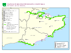
Find out about the work being carried out to improve public access to each stretch of the coast in the south east of England.

Stretch name Progress
Shoreham-by-Sea to Eastbourne Open to the public
Eastbourne to Camber:
Eastbourne Pier to Rye Harbour
Stage 5: Approved (not yet available for public use - work to establish the route is currently taking place)
Eastbourne to Camber:
Rye Harbour to Camber Sands
Stage 2 and 3: Develop and Propose
Camber to Folkestone Open to the public
Folkestone to Ramsgate Open to the public
Ramsgate to Whitstable Open to the public
Isle of Sheppey Stage 4 and 5: Partially approved (not yet available for public use - work to establish the route is currently taking place on approved lengths)
Whitstable to Iwade Open to the public
Iwade to Grain - Ridham Dock to Kingsferry Bridge Open to the public
Iwade to Grain - Kingsferry Bridge to Otterham Quay Stage 4: Determine
Iwade to Grain - Otterham Quay to Stoke Marshes Open to the public
Iwade to Grain - Grain Crossing to Grain Esplanade Stage 5: Open (not yet available for public use - work to establish the route is currently taking place)
Grain to Woolwich Open to the public
Published 10 September 2014
Last updated 25 October 2023 +show all updates
  1. Map and table updated to show the Ramsgate to Whitstable stretch is now open to the public.

  2. Map and table updated to show the Otterham Quay to Stoke Marshes section of the Iwade to Grain stretch is now open to the public.

  3. Map and table updated to show a further section of the Eastbourne to Camber stretch has been approved.

  4. Map and table updated to show that the Whitstable to Iwade stretch and part 1 of the Iwade to Grain stretch (Ridham Dock to Kingsferry Bridge) are now open to the public.

  5. Map and table updated to show parts of the Isle of Sheppey stretch have been approved.

  6. Map and table updated to show the Shoreham-by-Sea to Eastbourne stretch is now open to the public.

  7. Map updated as another section of the Eastbourne to Camber stretch has been approved.

  8. Map and table updated to show the Grain to Woolwich stretch is now open to the public.

Related Articles

Comments

  1. We don't have any comments for this article yet. Why not join in and start a discussion.

Write a Comment

Your name:
Your email:
Comments:

Post my comment

Recent Comments

Follow Us on Twitter

Share This


Enjoyed this? Why not share it with others if you've found it useful by using one of the tools below: