This file may not be suitable for users of assistive technology.
Request an accessible format.
If you use assistive technology (such as a screen reader) and need a version of this document in a more accessible format, please email enquiries@naturalengland.org.uk. Please tell us what format you need. It will help us if you say what assistive technology you use.
Details
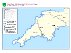
This region has the South West Coast Path national trail along its coastline.
Find out about the work being carried out to improve public access to each stretch of the coast in the south west of England.
Stage 5: Open (not yet available for public use - work to establish the route is currently taking place)
Published 6 September 2012 Last updated 23 November 2023 +show all updates
Map and table updated to show that the remaining sections of Combe Martin to Marsland Mouth, plus VR11 have been approved. This stretch is now at stage 5. A further 2 lengths of the Cremyll to Kingswear stretch have been approved.
Map and table updated to show that all sections of the Marsland Mouth to Newquay and Penzance to St Mawes stretches are now approved.
Map and table updated to show the remaining length (SMC2) on the St Mawes to Cremyll stretch has been approved.
Map and table updated to show that the Kingswear to Lyme Regis and Minehead to Combe Martin stretches are now at stage 5.
Map and table updated to show that some sections of the Combe Martin to Marsland Mouth and Cremyll to Kingswear stretches have been approved.
Map and table updated to show the Newquay to Penzance stretch is now at stage 5.
Map and table updated to show that some sections of the Marsland Mouth to Newquay stretch have been approved.
Map and table updated to show that some sections of the Penzance to St Mawes stretch have been approved.
Map and table updated to show that some sections of the St Mawes to Cremyll and Newquay to Penzance stretches have been approved.